If you live in Pitt Meadows, chances are you have heard people talking about the North Lougheed Area Plan. Depending on who you ask, it is either an exciting opportunity, a source of concern, or one of the most important planning decisions the city has faced in decades.
The North Lougheed Area Plan, often referred to as the NLAP, will shape how approximately 125 acres of land on the north side of Lougheed Highway between Harris Road and Meadows Gardens Golf Club may develop over the coming decades.
For a small city like Pitt Meadows, this is a big deal.
This area sits at one of the most visible and strategically important locations in the community. It is close to Harris Road, the West Coast Express station, Meadowtown Centre, and the Golden Ears and Pitt River bridges. How this land develops will influence housing, traffic, jobs, parks, and the overall character of Pitt Meadows for generations.
The North Lougheed Area Plan is a detailed land use plan and set of development policies created by the City of Pitt Meadows to guide future development in the North Lougheed Study Area.
Think of it as a blueprint.
It does not approve any specific building or development. Instead, it establishes the long-term vision for what types of uses may be allowed, where roads and parks could go, and how the area should evolve over time.
In planning terms, the NLAP will become part of Pitt Meadows' Official Community Plan, which is the City's overarching roadmap for growth through 2040.
The North Lougheed Study Area covers approximately 125 acres, or about 50 hectares, on the north side of Lougheed Highway. It stretches from Harris Road in the west to Meadows Gardens Golf Club in the east.
For local residents, this includes a large area that is currently underutilized but highly visible to anyone driving through Pitt Meadows.
Because of its size and location, many people see it as one of the most significant future development areas in Pitt Meadows real estate.
This plan is about much more than a few new buildings.
The North Lougheed Area Plan will influence:
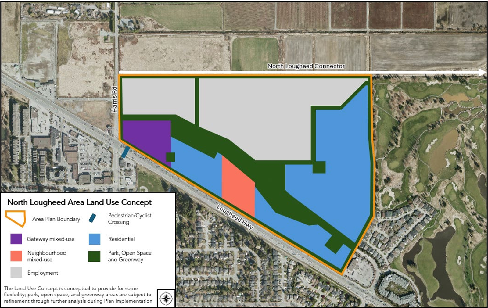
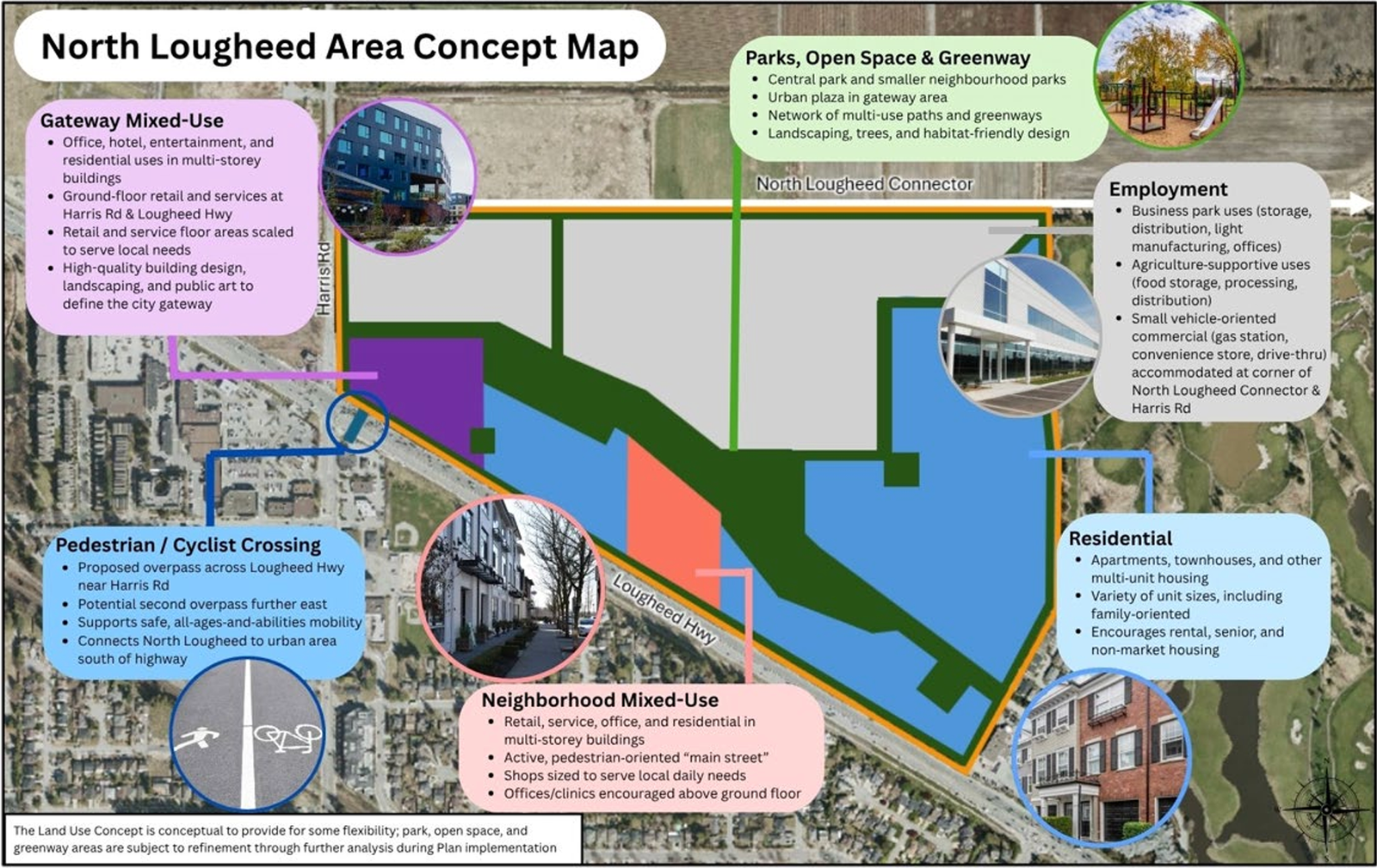
The City has described the North Lougheed Area as an opportunity for a mixed-use, transit-supportive community that may include:
• Apartments and condominiums
• Townhomes
• Commercial and retail space
• Office and employment uses
• Parks and public gathering spaces
• New road and transportation infrastructure
In other words, the vision is not simply to add housing. It is to create a complete community.
Although work on the North Lougheed Area Plan has been underway for several years, it returned to Council in 2026 for further review and updated public engagement. The City posted a revised draft plan presented to Council on May 12, 2026 and indicated additional community engagement would follow in the spring before moving toward a public hearing and final decisions.
Pitt Meadows is also under pressure to increase housing supply.
The Province of British Columbia has assigned Pitt Meadows a five-year housing target of 727 net new homes by August 2030.
One of the biggest questions residents have is traffic.
Any major development in the North Lougheed Area will require careful planning around road capacity, transit, pedestrian connections, and access to Lougheed Highway and Harris Road.
The proposed North Lougheed Connector, a future road linking Abernathy Way to Lougheed Highway, is intended to improve access and reduce congestion on Old Dewdney Trunk Road while helping support growth in this area. 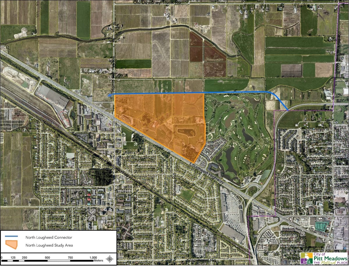
For homeowners and buyers, large planning initiatives often create both opportunities and uncertainty.
Potential benefits include:
• More housing choices
• Additional shops and services
• Improved infrastructure
• Increased local investment
• Greater long-term economic activity
At the same time, some residents have concerns about density, traffic, and preserving the small-town character that makes Pitt Meadows unique.
Both perspectives are valid, and that is why community engagement is such an important part of the process.
As someone who lives and works in Pitt Meadows real estate, I believe the North Lougheed Area Plan is one of the most significant development projects our community has seen in years.
Whether you are excited, skeptical, or simply curious, it is worth paying attention to.
This is the kind of project that can shape housing options, amenities, and property values for decades to come. For current homeowners, future buyers, and families considering a move to Pitt Meadows, understanding what is happening now will help you make better real estate decisions in the future.
Some 2020 policies were removed because they have since been incorporated into more recent City plans and strategies (e.g., the Climate Action Strategy) that also help to shape future development.
A revised conceptual land use plan is also included in the 2026 draft Area Plan. The land use concept changes were informed by a recent commercial retail market study, market changes, and further consideration of local features (e.g., watercourses and adjacent agricultural land).
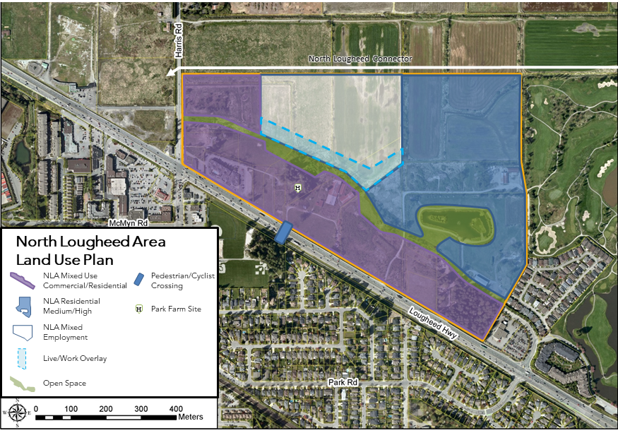
In 2011, a comprehensive land use plan was prepared for the North Lougheed Area that built on years of previous planning for the southern portion of the area. The 2011 plan identified a combination of mixed employment and retail commercial uses.
A commercial and industrial land study completed in 2019 for the City’s Official Community Plan (OCP) review, however, indicated that the market had changed significantly and that there was no longer a need for the amount of retail commercial space included in the 2011 plan. This meant that the 2011 plan was no longer economically viable, and a revised comprehensive land use concept was required to meet community and regional needs.
In 2019, the City initiated a multi-phase technical review and engagement process to develop a new land use concept that built on both the previous planning work, and more recent OCP review process. Listed below are some of the key project milestones between 2018 and 2020:
• November 2018 – Council directed staff to re-examine the project and to make recommendations on moving forward with the North Lougheed Area Plan.
• May 2019 – A scoping report was presented to Council describing the recommended timeline for engaging the public, updating technical studies and revising the land use plan.
• July 2019 – Staff made a Council Presentation on preliminary findings from July community engagement.
• October 22, 2019 – Three draft land use concepts were presented to Council.
• October 29, 2019 – A fourth draft land use concept was presented to Council.
• May 2020 – North Lougheed Land Use Plan, land use designations and policies, and summary of Phase 2 community engagement presented to Council.
• July 2020 - Council endorsed the revised North Lougheed Land Use Plan and development policies that were drafted with input from extensive public and stakeholder engagement.
• September 2020 - Council granted first and second reading to OCP Amendment for NLAP.
From 2020 to 2026, the City has focused on additional technical work and collaborative planning with q̓ic̓əy̓. These efforts are intended to support early consideration of cultural context and ensure that q̓ic̓əy̓ perspectives are reflected in the Area Plan, helping to improve understanding, reduce uncertainty and avoid unintended impacts as the area develops.
More recent community engagement has included:
• Summer 2019 - Feedback was collected from the community and stakeholders both online and at several engagement pop-up events throughout the summer.
• November 2019 to February 2020 - Using the information and ideas received in summer 2019, four NLSA draft land use concepts were developed and shared with the public for input online and at engagement events.
Building heights in the study area are limited to a maximum of 45.7m (150 feet) above the elevation of the Pitt Meadows Airport runway, due to federal flight path safety restrictions. Ground floors of the buildings must meet the City’s Floodplain Designation and Construction Control Bylaw elevation requirements. Together, these regulations restrict the maximum height of future development.
Development within the area will also require that property owners submit the necessary development applications for the City’s review. Please see the City’s Property Development webpage for more information about development application processes.
And that is not an exaggeration.
The North Lougheed Area Plan, often referred to as the NLAP, will shape how approximately 125 acres of land on the north side of Lougheed Highway between Harris Road and Meadows Gardens Golf Club may develop over the coming decades.
For a small city like Pitt Meadows, this is a big deal.
This area sits at one of the most visible and strategically important locations in the community. It is close to Harris Road, the West Coast Express station, Meadowtown Centre, and the Golden Ears and Pitt River bridges. How this land develops will influence housing, traffic, jobs, parks, and the overall character of Pitt Meadows for generations.
What Is the North Lougheed Area Plan?
The North Lougheed Area Plan is a detailed land use plan and set of development policies created by the City of Pitt Meadows to guide future development in the North Lougheed Study Area.
Think of it as a blueprint.
It does not approve any specific building or development. Instead, it establishes the long-term vision for what types of uses may be allowed, where roads and parks could go, and how the area should evolve over time.
In planning terms, the NLAP will become part of Pitt Meadows' Official Community Plan, which is the City's overarching roadmap for growth through 2040.
Where Is the North Lougheed Study Area?
The North Lougheed Study Area covers approximately 125 acres, or about 50 hectares, on the north side of Lougheed Highway. It stretches from Harris Road in the west to Meadows Gardens Golf Club in the east.
For local residents, this includes a large area that is currently underutilized but highly visible to anyone driving through Pitt Meadows.
Because of its size and location, many people see it as one of the most significant future development areas in Pitt Meadows real estate.
Why This Matters to Pitt Meadows Residents
This plan is about much more than a few new buildings.
The North Lougheed Area Plan will influence:
- • How many new homes could be built
- • Whether shops, restaurants, and services are added
- • What transportation improvements are needed
- • Where parks and public spaces are located
- • How traffic is managed
- • How the entrance to Pitt Meadows may look in the future
What Types of Development Are Being Considered?
The City has described the North Lougheed Area as an opportunity for a mixed-use, transit-supportive community that may include:
• Apartments and condominiums
• Townhomes
• Commercial and retail space
• Office and employment uses
• Parks and public gathering spaces
• New road and transportation infrastructure
In other words, the vision is not simply to add housing. It is to create a complete community.
Why the Plan Is Back at Council in 2026
Although work on the North Lougheed Area Plan has been underway for several years, it returned to Council in 2026 for further review and updated public engagement. The City posted a revised draft plan presented to Council on May 12, 2026 and indicated additional community engagement would follow in the spring before moving toward a public hearing and final decisions.
This reflects how complex large planning projects can be. Market conditions, transportation studies, public feedback, and provincial housing pressures all influence the final outcome.
Provincial Housing Targets Add Pressure
Pitt Meadows is also under pressure to increase housing supply.
The Province of British Columbia has assigned Pitt Meadows a five-year housing target of 727 net new homes by August 2030.
While the City does not build housing directly, plans like the North Lougheed Area Plan are essential because they create the policy framework needed for future development when market conditions improve.
Traffic and Infrastructure Considerations
One of the biggest questions residents have is traffic.
Any major development in the North Lougheed Area will require careful planning around road capacity, transit, pedestrian connections, and access to Lougheed Highway and Harris Road.
The proposed North Lougheed Connector, a future road linking Abernathy Way to Lougheed Highway, is intended to improve access and reduce congestion on Old Dewdney Trunk Road while helping support growth in this area.
What This Could Mean for Pitt Meadows Real Estate
For homeowners and buyers, large planning initiatives often create both opportunities and uncertainty.
Potential benefits include:
• More housing choices
• Additional shops and services
• Improved infrastructure
• Increased local investment
• Greater long-term economic activity
At the same time, some residents have concerns about density, traffic, and preserving the small-town character that makes Pitt Meadows unique.
Both perspectives are valid, and that is why community engagement is such an important part of the process.
My Take as a Pitt Meadows Realtor
As someone who lives and works in Pitt Meadows real estate, I believe the North Lougheed Area Plan is one of the most significant development projects our community has seen in years.
Whether you are excited, skeptical, or simply curious, it is worth paying attention to.
This is the kind of project that can shape housing options, amenities, and property values for decades to come. For current homeowners, future buyers, and families considering a move to Pitt Meadows, understanding what is happening now will help you make better real estate decisions in the future.
Frequently Asked Questions:
What are the benefits of developing the North Lougheed Area?
Developing the North Lougheed Area has many benefits, including:
Variety of housing options - Mixed-use and multi-family developments are being considered to help address the city’s housing needs.Close to transit - The location allows for housing, employment, a potential post-secondary educational campus and recreational amenities—all within a five-minute walking distance to transit.
Space for local businesses and jobs - Economic development will be enhanced with more space for growing local businesses and sustainable jobs.
Increased tax base - Property taxes will be spread among a greater range of land uses and allow for enhanced services and amenities for the community.
Agricultural benefits, including improved safety - Traffic calming along Old Dewdney Trunk Road and diverting traffic onto the new North Lougheed Connector (NLC) will reduce traffic volumes in the agricultural area, improving safety for slower moving farm vehicles and machinery.
Reduced congestion and improvements to traffic flow - Development will support the construction of the NLC. Tied to other highway improvement projects, this will reduce traffic congestion and improve traffic flow. The NLC will also provide a secondary arterial connection to north Maple Ridge.
Improved north/south community connectivity - In addition to the NLC, a proposed pedestrian and cyclist overpass connecting with Harris Road Park will improve community access across Lougheed Highway.
What is the difference between the draft North Lougheed Area Plan prepared in 2020 and the draft North Lougheed Area Plan prepared in 2026? - The 2020 draft Area Plan included a range of policies and a land use plan to guide new development in the North Lougheed Area. The policies were arranged according to six guiding principles:
• New and enhanced policies that aim to recognize the historic and ongoing significance of the lands to q̓ic̓əy̓ (Katzie) First Nation.
• Consolidation of other policies, and the addition of new policies, into the following sections:
• Neighbourhood Character – policies fostering a strong neighbourhood character in the North Lougheed Area that honours the past and contributes to the city’s small-town feel.
• Land Use – policies facilitating a variety of uses, including new housing and employment opportunities, that contribute to the city’s long-term sustainability.
• Transportation – policies promoting a safe, multi-modal mobility network that supports active transportation and public transit.
• Parks and Community Amenities – policies ensuring the North Lougheed Area provides for a variety of high-quality park and community amenities to support community spirit and wellbeing.
• Agriculture – policies protecting surrounding agricultural areas from urban development within the North Lougheed Area, and encouraging opportunities for appropriately scaled agriculture and supporting uses.
• Environment – policies conserving and enhancing natural features within the North Lougheed Area and promoting climate-resilient urban development.
• Utility Services – policies identifying that development within the North Lougheed Area will be serviced with City water, sanitary and stormwater systems.
• Implementation – policies outlining key implementation steps that are meant to be undertaken before development in the North Lougheed Area.
Increased tax base - Property taxes will be spread among a greater range of land uses and allow for enhanced services and amenities for the community.
Agricultural benefits, including improved safety - Traffic calming along Old Dewdney Trunk Road and diverting traffic onto the new North Lougheed Connector (NLC) will reduce traffic volumes in the agricultural area, improving safety for slower moving farm vehicles and machinery.
Reduced congestion and improvements to traffic flow - Development will support the construction of the NLC. Tied to other highway improvement projects, this will reduce traffic congestion and improve traffic flow. The NLC will also provide a secondary arterial connection to north Maple Ridge.
Improved north/south community connectivity - In addition to the NLC, a proposed pedestrian and cyclist overpass connecting with Harris Road Park will improve community access across Lougheed Highway.
What is the difference between the draft North Lougheed Area Plan prepared in 2020 and the draft North Lougheed Area Plan prepared in 2026? - The 2020 draft Area Plan included a range of policies and a land use plan to guide new development in the North Lougheed Area. The policies were arranged according to six guiding principles:
- 1. All development should celebrate the natural, built, and cultural heritage and identity of Pitt Meadows and the North Lougheed Area.
- 2. All development proposals should directly address climate change adaptation, employ greenhouse gas (GHG) emission reduction and green building strategies, and increase or enhance available wildlife habitat to increase the environmental resilience of the community.
- 3. All development should support sustainable transportation choices.
- 4. All development should contribute to the economic vitality of the community.
- 5. All developments should contribute to community wellness and inclusivity.
- 6. All developments should incorporate buffering, transitioning, and/or mitigation strategies to address real or perceived conflicting needs between different land uses.
• New and enhanced policies that aim to recognize the historic and ongoing significance of the lands to q̓ic̓əy̓ (Katzie) First Nation.
• Consolidation of other policies, and the addition of new policies, into the following sections:
• Neighbourhood Character – policies fostering a strong neighbourhood character in the North Lougheed Area that honours the past and contributes to the city’s small-town feel.
• Land Use – policies facilitating a variety of uses, including new housing and employment opportunities, that contribute to the city’s long-term sustainability.
• Transportation – policies promoting a safe, multi-modal mobility network that supports active transportation and public transit.
• Parks and Community Amenities – policies ensuring the North Lougheed Area provides for a variety of high-quality park and community amenities to support community spirit and wellbeing.
• Agriculture – policies protecting surrounding agricultural areas from urban development within the North Lougheed Area, and encouraging opportunities for appropriately scaled agriculture and supporting uses.
• Environment – policies conserving and enhancing natural features within the North Lougheed Area and promoting climate-resilient urban development.
• Utility Services – policies identifying that development within the North Lougheed Area will be serviced with City water, sanitary and stormwater systems.
• Implementation – policies outlining key implementation steps that are meant to be undertaken before development in the North Lougheed Area.
Some 2020 policies were removed because they have since been incorporated into more recent City plans and strategies (e.g., the Climate Action Strategy) that also help to shape future development.
A revised conceptual land use plan is also included in the 2026 draft Area Plan. The land use concept changes were informed by a recent commercial retail market study, market changes, and further consideration of local features (e.g., watercourses and adjacent agricultural land).
What informed the preparation of the 2026 draft North Lougheed Area Plan?
The preparation of the 2026 draft Area Plan was informed by:- • The extensive planning and public engagement work undertaken in 2019 and 2020, including the Area Plan presented to Council in September 2020
- • Further input from government agencies, interest holders and q̓ic̓əy̓ (Katzie) First Nation
- • Policies, plans and assessments developed since 2020, including the 2022 OCP, 2023 Agricultural Viability Strategy, 2023 Active Transportation Plan, 2024 Urban Forest Strategy, 2025 Climate Action Strategy, and 2025 Complete Communities Assessment
What has been the project timeline to date?
The North Lougheed Area has been the subject of various planning initiatives and applications to the Agricultural Land Commission (ALC) since the 1980s.In 2011, a comprehensive land use plan was prepared for the North Lougheed Area that built on years of previous planning for the southern portion of the area. The 2011 plan identified a combination of mixed employment and retail commercial uses.
A commercial and industrial land study completed in 2019 for the City’s Official Community Plan (OCP) review, however, indicated that the market had changed significantly and that there was no longer a need for the amount of retail commercial space included in the 2011 plan. This meant that the 2011 plan was no longer economically viable, and a revised comprehensive land use concept was required to meet community and regional needs.
In 2019, the City initiated a multi-phase technical review and engagement process to develop a new land use concept that built on both the previous planning work, and more recent OCP review process. Listed below are some of the key project milestones between 2018 and 2020:
• November 2018 – Council directed staff to re-examine the project and to make recommendations on moving forward with the North Lougheed Area Plan.
• May 2019 – A scoping report was presented to Council describing the recommended timeline for engaging the public, updating technical studies and revising the land use plan.
• July 2019 – Staff made a Council Presentation on preliminary findings from July community engagement.
• October 22, 2019 – Three draft land use concepts were presented to Council.
• October 29, 2019 – A fourth draft land use concept was presented to Council.
• May 2020 – North Lougheed Land Use Plan, land use designations and policies, and summary of Phase 2 community engagement presented to Council.
• July 2020 - Council endorsed the revised North Lougheed Land Use Plan and development policies that were drafted with input from extensive public and stakeholder engagement.
• September 2020 - Council granted first and second reading to OCP Amendment for NLAP.
A public hearing scheduled for November 5, 2020 was cancelled to accommodate further discussions and engagement with various interest holders and organizations.
From 2020 to 2026, the City has focused on additional technical work and collaborative planning with q̓ic̓əy̓. These efforts are intended to support early consideration of cultural context and ensure that q̓ic̓əy̓ perspectives are reflected in the Area Plan, helping to improve understanding, reduce uncertainty and avoid unintended impacts as the area develops.
How is the community being consulted?
Over the years, there have been many rounds of community engagement for the North Lougheed Area Plan, including a public hearing in 2012, before the City applied to the Agricultural Land Commission to exclude the remaining part of the area from the Agricultural Land Reserve.More recent community engagement has included:
• Summer 2019 - Feedback was collected from the community and stakeholders both online and at several engagement pop-up events throughout the summer.
• November 2019 to February 2020 - Using the information and ideas received in summer 2019, four NLSA draft land use concepts were developed and shared with the public for input online and at engagement events.
In May 2020, a summary of the 2019-2020 public and stakeholder engagement was presented to Council along with the North Lougheed Land Use Plan, land use designations and policies.
It is anticipated that there will be additional opportunities for the community to provide feedback as preparation of the North Lougheed Area Plan proceeds, including a public hearing on the proposed Area Plan.
• allow for traffic calming on Old Dewdney Trunk Road to make it safer for area residents and slower moving farm vehicles and machinery; and
• provide a secondary traffic corridor to north Maple Ridge.
When was the North Lougheed Area excluded from the Agricultural Land Reserve?
The Agricultural Land Commission (ALC) agreed to a variety of conditional exclusions from the Agricultural Land Reserve (ALR) between 1985 and 2004. In 2013, the City received conditional approval by the ALC to exclude the remaining northern portion of the North Lougheed Study Area. There have been several developments which have met the exclusion conditions, including the Best Western (built in 1996) and the Nissan dealership (built in 2003), and are no longer in the ALR.What is the North Lougheed Connector?
The proposed 2-kilometre North Lougheed Connector (NLC) is required by the Agricultural Land Commission as part of their conditional approval and will provide a direct link from Abernethy Way to the Lougheed Highway, at Harris Road. The NLC is intended to:• allow for traffic calming on Old Dewdney Trunk Road to make it safer for area residents and slower moving farm vehicles and machinery; and
• provide a secondary traffic corridor to north Maple Ridge.
Staff are working with the Ministry of Transportation and Transit and TransLink to determine how the NLC will connect to Golden Ears Way and to Lougheed Highway west of Harris Road. This work is anticipated to be tied to other highway improvement projects to improve traffic flow in the area.
What type of development is being proposed for the area?
The NLAP will guide the creation of a complete neighbourhood development that incorporates a mix of public green spaces, cultural heritage, and residential, commercial and employment uses. The vision for the North Lougheed Area is an inclusive, connected and resilient neighbourhood that acknowledges q̓ic̓əy̓, fosters a small-town feel, and provides opportunities to live, work, play and learn.Are high rise towers proposed for the area?
The City may consider buildings over six storeys in height in specific areas, provided they respond to concerns around privacy, views, shading, and surrounding land use sensitivities. Taller buildings will take advantage of prominent views of the surrounding landscape, while also reducing the per capita costs of infrastructure and services.Building heights in the study area are limited to a maximum of 45.7m (150 feet) above the elevation of the Pitt Meadows Airport runway, due to federal flight path safety restrictions. Ground floors of the buildings must meet the City’s Floodplain Designation and Construction Control Bylaw elevation requirements. Together, these regulations restrict the maximum height of future development.
When will development in the North Lougheed Area start?
Following the completion of the North Lougheed Area Plan, a number of additional steps will be required before development proceeds within the area, including an amendment to the Regional Growth Strategy and the satisfaction of the various Agricultural Land Commission exclusion conditions.Development within the area will also require that property owners submit the necessary development applications for the City’s review. Please see the City’s Property Development webpage for more information about development application processes.